Maps


Search  Inquiry Net

Back ] Home ] Up ] Next ]

Activities
Archery
Axe, Boy Scout
Axe, Saw, Forestry
Axe, Saw,  Knife
Axe Use: Beard
Axe Use: Seton
Axe Use: Traditional
Axe Throwing
Beds, Woodcraft
Bedding Materials
Bicycle Maintenance
Birch-Bark Torch
Birds
Bird Houses
Blocks Tackles Purchase
Blood Red Cross
Broom: Camp or Witch's
Buttons
Campcraft
Camp Hygiene
Camp Planning
Campfire Programs
Catapult
Chainsaws
Checklists
Chuck Box Riddance!
City-Craft
Compass Bear Song
Compass, Home-Made
Cooking
Cotton Kills Bear Song
Deduction in Tracking
Deduction & Detective
Drum
Dyes
Edible Plants
Equipment, Leader
Equipment, Personal
Equipment Maintenance
Equipment, Lightweight
Equip, Pickle Bucket Camp
Estimation
Field Signals
Fire-Building
Fire Building
Fire Laying
Fire Lighting
Fire Starters
Fire: Rubbing-Stick
Fire Types, Wood Types
Fire Council Ring
Fires: Woodcraft
First Aid
First Class Journey
Flint & Steel
Flowers
Forest
Gesture Signals
Ground to Air Signals
Handicraft Stunts
High Adventure
Hiking
Hike Planning
Indian Sundial Clock
Insect Collecting
Insect Preserve
Indian Well
Knife & Hatchet
Knots, Bends, Hitches
Knots: Diamond Hitch
Knots: Lashings
Knots: Rope Work
Knots: Seton
Knots: Traditional
Knots & Whipping
Lashings
Lashing Practice Box
Lace or Thong
Learn by Doing
Leave No Trace
Leave No Trace
Lights
Local Knowledge
Log Ladders, Notched
Log-Rolling
Logs: Cut Notch
Logs Split with Axe
Loom and Grass Mats
Lost in the Woods
Manners
Maps
Map & Compass
Maps: Without Compass
Measurement
Measurement Estimation
Menu Worksheet
Menu (Adult IOLS)
Mosquitoes
Mushrooms
Night Tracking
Observation
Old Trails
Paints
Pioneering, Basic
Pioneering Models
Plaster Casts
Preparations
Proverbs
Rake
Rope Care
Rope Making
Rope Spinning
Scout Reports
Signal & Sign
Sign Language
Silent Scout Signals
Smoke Prints
Snakes
Spanish Windlass
Spoons
Staff/Stave Making
Stalking Skills
Stalking & Observation
Stars
Stools
Story Telling
Stoves & Lanterns
Summoning Help
Sun Dial: Scientific
Survival Kit
Tarp Poles
Teepee (4 Pole)
Tent Care
Tent Pitching
Tom-Tom
Tomahawk Throwing
Tomahawk Targets
Totem Making
Totem Animals
Totem Poles
Training in Tracking
Tracks, Ground, Weather
Tracking & Trailing
Trail Following
Trail Signs & Blazes
Trail Signs of Direction
Trail Signs: Traditional
Trail Signs for Help
Trees of the NE
Wall Hangings
Watch Compass
Weather Wisdom
Wild Things

Scout Books

Site Contents

Map reading is an art. Spend some time just sitting at home looking at various maps and learn to read them like a picture book.

Which Map?

The first thing that you have to decide is what scale of map is suited to your purpose.

The scale of the map is always printed on the front cover and is expressed as the ratio between a unit of length on the map and the equivalent distance on the ground. 

The scale of 1:25,000 means that one unit of length on the map is equivalent to 25,000 units on the ground, or, to put it into actual units, one centimeter is equivalent to 25,000 centimeters or 250 meters.

In the same way 1:50,000 means that 1cm on the map is equivalent to 50,000 centimeters or 500 meters on the ground.

Some common map scales and their uses:

Scale

Meaning

Use

1:10,000  1cm= 100m Orienteering
1:25,000  1cm = 250m Ideal far walking, but you may require mare than one map.
1:50,000  1cm = 500m Most popular for walkers.
1:63,360 1 inch = 1 mile Now replaced by 1:50,000 maps.
1:100,000 1cm= 1,000 meters  Cycling, hastening, routes.
1:250,000 1cm = 2,500 meters  Cycling, motoring, etc.
1:1,000,000 1 cm = 10km  Map of a country

For the hill walker the choice seems to be between the 1:50,000 and 1:25,000.

Obviously it is possible to show far more detail on the larger scale map, but this advantage is offset by the fact that you may need to carry four times as much map. 

Contour Lines

Contour Lines are lines which join points of equal distance.

These lines (usually colored light brown) form patterns on the map. They show mountains, valleys, ridges and the exact shape of slopes.

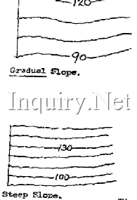
Numbers on the contour lines always face up-hill.

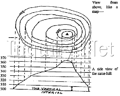
The distance from one contour line to another is always the same, e.g.. the hill above, has a vertical interval of 10 meters between each line. All points on a contour line are exactly the same height above Sea Level.

From this skill we can quickly see that what we see on the map may not be seen when in the field. Maps cannot show hills and valleys in relief, but does so by the contours.

Contours

A Contour line is an imaginary line joining points on the ground which are the same height.  These contours are shown by an orange line (1:50,000 & 1:25,000). The shape of the contours indicates the shape of the ground slowly, but when they are close together then the ground level changes rapidly. These lines are continuous, except at a vertical cliff face where they merge. The interval between the lines varies according to the scale of the map.

1:25,000 - vertical interval of 25 feet.

1:50,000 - vertical interval of 50 feet with the contour values given to the nearest METER.

Contour lines are thickened on up-to-date maps. Every 100 feet on 1:25,000 scale; every 200 feet on 1 inch - 1 mile scale; every 70 meters on 1:50,000 scale, the latter corresponding to the nearest metric conversion of 250 feet.

Journey Planning

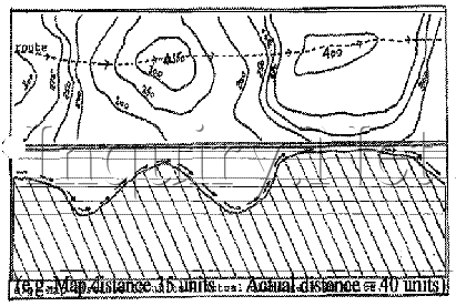
When planning a journey across open country the walker must never forget to read the map properly. What seems a walk of about 20 miles on a flat sheet of paper (the map) may not be quite so easy, or even the 20 miles planned, due to hills, valleys, and private property. Never forget to calculate the distance you need to cover taking into consideration that you may have to walk up and down hills.

Marginal Data

After making a choice of the map you require, a need to become conversant with the information it contains is essential. All the information that you require can be found somewhere in the margins of the map.

It is essential to study the information contained in these margins, for it shows a lot of detail that is important to the use and understanding of the map. The information does vary from map to map, but as a general rule the information is the same.

What can be found?

bulletTITLE: North Works Moors, Alnwick, etc.. SHEET NUMBER: SHEET 94, etc.....
bulletSCALE: 1:25,000 - 1:50,000 etc.....
bulletFEATURES: Roads, public rights of way, railways, general features (Symbols and conventional signs).
bulletRELIEF: How the contours are shown, their values and contour interval.
bulletBOUNDARIES: County, Parish, etc....
bulletSCALE: Straight line scale for measurement of distance.
bulletGRID REFERENCE: Determines the grid letters of the I00km square, i.e.. SE.
bulletNORTH POINTS: True North, Grid North, Magnetic North.
bulletVARIATIONS: Information on the difference between Grid and Magnetic North.
bulletCOMPLETION AND REVISION DATES:  Once the information found in the margins is learned, then very quickly the map reader can plan, estimate journey times, and most importantly picture in his mind what the map shows in a picture form.


bulletALWAYS TRY TO USE THE MOST UP TO DATE ISSUE OF MAPS THAT YOU ARE ABLE.
bulletFEATURES CHANGE QUICKLY - YESTERDAY THERE MAY HAVE BEEN A LARGE WOOD THERE - TODAY IT IS GONE.
bulletGIVE THE SCOUTS THE BEST YOU CAN -- IT AVOIDS ACCIDENTS!

See Also:

Compass Work

Finding Direction Without a Compass

Traditional Training Handbook
©2003 Baden-Powell Scouts Association


Additional Information:

Peer- Level Topic Links:
Activities ] Archery ] Axe, Boy Scout ] Axe, Saw, Forestry ] Axe, Saw,  Knife ] Axe Use: Beard ] Axe Use: Seton ] Axe Use: Traditional ] Axe Throwing ] Beds, Woodcraft ] Bedding Materials ] Bicycle Maintenance ] Birch-Bark Torch ] Birds ] Bird Houses ] Blocks Tackles Purchase ] Blood Red Cross ] Broom: Camp or Witch's ] Buttons ] Campcraft ] Camp Hygiene ] Camp Planning ] Campfire Programs ] Catapult ] Chainsaws ] Checklists ] Chuck Box Riddance! ] City-Craft ] Compass Bear Song ] Compass, Home-Made ] Cooking ] Cotton Kills Bear Song ] Deduction in Tracking ] Deduction & Detective ] Drum ] Dyes ] Edible Plants ] Equipment, Leader ] Equipment, Personal ] Equipment Maintenance ] Equipment, Lightweight ] Equip, Pickle Bucket Camp ] Estimation ] Field Signals ] Fire-Building ] Fire Building ] Fire Laying ] Fire Lighting ] Fire Starters ] Fire: Rubbing-Stick ] Fire Types, Wood Types ] Fire Council Ring ] Fires: Woodcraft ] First Aid ] First Class Journey ] Flint & Steel ] Flowers ] Forest ] Gesture Signals ] Ground to Air Signals ] Handicraft Stunts ] High Adventure ] Hiking ] Hike Planning ] Indian Sundial Clock ] Insect Collecting ] Insect Preserve ] Indian Well ] Knife & Hatchet ] Knots, Bends, Hitches ] Knots: Diamond Hitch ] Knots: Lashings ] Knots: Rope Work ] Knots: Seton ] Knots: Traditional ] Knots & Whipping ] Lashings ] Lashing Practice Box ] Lace or Thong ] Learn by Doing ] Leave No Trace ] Leave No Trace ] Lights ] Local Knowledge ] Log Ladders, Notched ] Log-Rolling ] Logs: Cut Notch ] Logs Split with Axe ] Loom and Grass Mats ] Lost in the Woods ] Manners ] [ Maps ] Map & Compass ] Maps: Without Compass ] Measurement ] Measurement Estimation ] Menu Worksheet ] Menu (Adult IOLS) ] Mosquitoes ] Mushrooms ] Night Tracking ] Observation ] Old Trails ] Paints ] Pioneering, Basic ] Pioneering Models ] Plaster Casts ] Preparations ] Proverbs ] Rake ] Rope Care ] Rope Making ] Rope Spinning ] Scout Reports ] Signal & Sign ] Sign Language ] Silent Scout Signals ] Smoke Prints ] Snakes ] Spanish Windlass ] Spoons ] Staff/Stave Making ] Stalking Skills ] Stalking & Observation ] Stars ] Stools ] Story Telling ] Stoves & Lanterns ] Summoning Help ] Sun Dial: Scientific ] Survival Kit ] Tarp Poles ] Teepee (4 Pole) ] Tent Care ] Tent Pitching ] Tom-Tom ] Tomahawk Throwing ] Tomahawk Targets ] Totem Making ] Totem Animals ] Totem Poles ] Training in Tracking ] Tracks, Ground, Weather ] Tracking & Trailing ] Trail Following ] Trail Signs & Blazes ] Trail Signs of Direction ] Trail Signs: Traditional ] Trail Signs for Help ] Trees of the NE ] Wall Hangings ] Watch Compass ] Weather Wisdom ] Wild Things ]

Parent- Level Topic Links:
Scuba ] Skills ] Games ] Shelter ] Fire ] Night ] B-P's Camping ] Hikes ] Indian ] Spring ] Summer ] Autumn ] Winter ]

The Inquiry Net Main Topic Links:
 [Outdoor Skills]  [Patrol Method [Old-School]  [Adults [Advancement]  [Ideals]  [Leadership]  [Uniforms]

Search This Site:

Search Amazon.Com:

When you place an order with Amazon.Com using the search box below, a small referral fee is returned to The Inquiry Net to help defer the expense of keeping us online.  Thank you for your consideration!

Search:

Keywords:

Amazon Logo


Scout Books Trading Post

Dead Bugs, Blow Guns, Sharp Knives, & Snakes:
What More Could A Boy Want?

Old School Scouting:
What to Do, and How to Do It!

To Email me, replace "(at)" below with "@"
Rick(at)Kudu.Net

If you have questions about one of my 2,000 pages here, you must send me the "URL" of the page!
This "URL" is sometimes called the "Address" and it is usually found in a little box near the top of your screen.  Most URLs start with the letters "http://"

The Kudu Net is a backup "mirror" of The Inquiry Net.  

©2003, 2011 The Inquiry Net, http://inquiry.net  In addition to any Copyright still held by the original authors, the Scans, Optical Character Recognition, extensive Editing,  and HTML Coding on this Website are the property of the Webmaster.   My work may be used by individuals for non-commercial, non-web-based activities, such as Scouting, research, teaching, and personal use so long as this copyright statement and a URL to my material is included in the text
The purpose of this Website is to provide access  to hard to find, out-of-print documents.  Much of the content has been edited to be of practical use in today's world and is not intended as historical preservation.   I will be happy to provide scans of specific short passages in the original documents for people involved in academic research.  


Last modified: October 15, 2016.